Disraeli Project: PGE
Ontario
Disraeli is located 40 kilometers north of Clean Air Metals Inc's TBN project and only 50 kilometers east from Impala Platinum Holdings Ltd's ("Implats") Lac Des Iles palladium Mine (Figure 1 and 2)

Figure 1: Illustration of Proterozoic Mid-Continent Rift and select associated copper-nickel-palladium-platinum deposits. The Eagle Mine operated by Lundin Mining hosts a Measured and Indicated Resource of 4.6 million tonnes grading 3.7% Ni, 3.1% Cu, 0.9 g/t Pt, 0.7 g/t Pd (2017 Lundin NI 43-101 report).
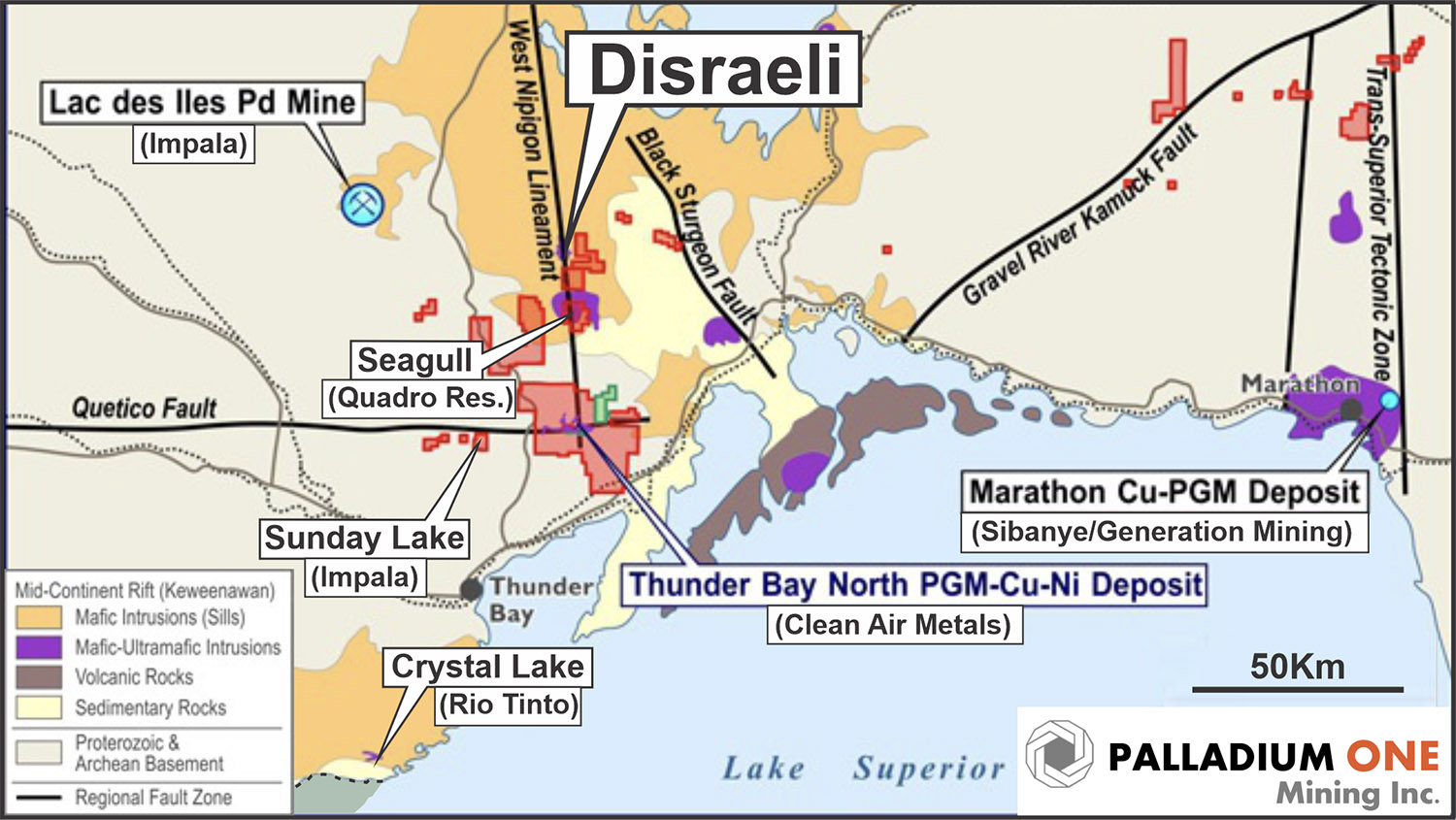
Figure 2: Illustrating the Nipigon Plate portion of the Proterozoic Mid-Continent Rift showing the West Nipigon Lineament which connects the Disraeli, Seagull and TBN intrusions. The Archean aged, Lac des Iles Palladium mine, located 50 kilometers west of Disraeli is also shown.
Preliminary Analysis
- The West Nipigon Lineament (Figure 2), is believed to be a control structure for the emplacement of the TBN (Clean Air Metals Inc.), Seagull (Quadro Resources Ltd.), and Disraeli intrusions and is prospective for additional magma conduits such as those found at TBN and Escape Lake.
- The high-resolution drone magnetic survey identified a very strong, reversely polarized magnetic body beneath the southeast bay (Hook Bay) of Disraeli Lake. (Figure 3 and 4).
- Reversely Polarized rocks are a key indicator for early mafic-ultramafic intrusives associated with PGE-Ni-Cu mineralization in the Mid-Continent Rift. Portions of the nearby TBN, Escape Lake, Sunday Lake (Implats), and Marathon (Generation Mining) deposits are also reversely polarized.
- The reversely polarized Hook Bay magnetic body is coincident with several AeroTEM EM anomalies that were outlined by a previous operator in 2011 and 2014 but were never drill tested (Figure 4 and 5).
- The presence of airborne AeroTEM EM anomalies suggest the possibility of not only disseminated mineralization but also semi massive or even massive sulphides.
- A lake sediment survey conducted in 2020 has shown a consistently greater ultramafic signature beneath Hook Bay compared to the rest of the Disraeli Lake. Ultramafic rocks were also observed along the western shore of Hook Bay. All of which point to this area being a much more primitive part of the Disraeli intrusion, and hence potentially close to the magma conduit which fed the intrusion.
- The Disraeli intrusion has seen much less exploration than adjacent intrusions in the Nipigon Plate, only 8 holes have been drilled on the property, and none have tested beneath Disraeli Lake. There is a precedent for magma conduits being located beneath lakes. Both TBN and Escape Lake magma conduits occur beneath the Current and Steepledge lakes, respectively.
Target Model
- High-grade PGE-rich Ni-Cu mineralization located within magma conduits similar to Clean Air Metals Inc.'s Thunder Bay North and Escape Lake deposits.
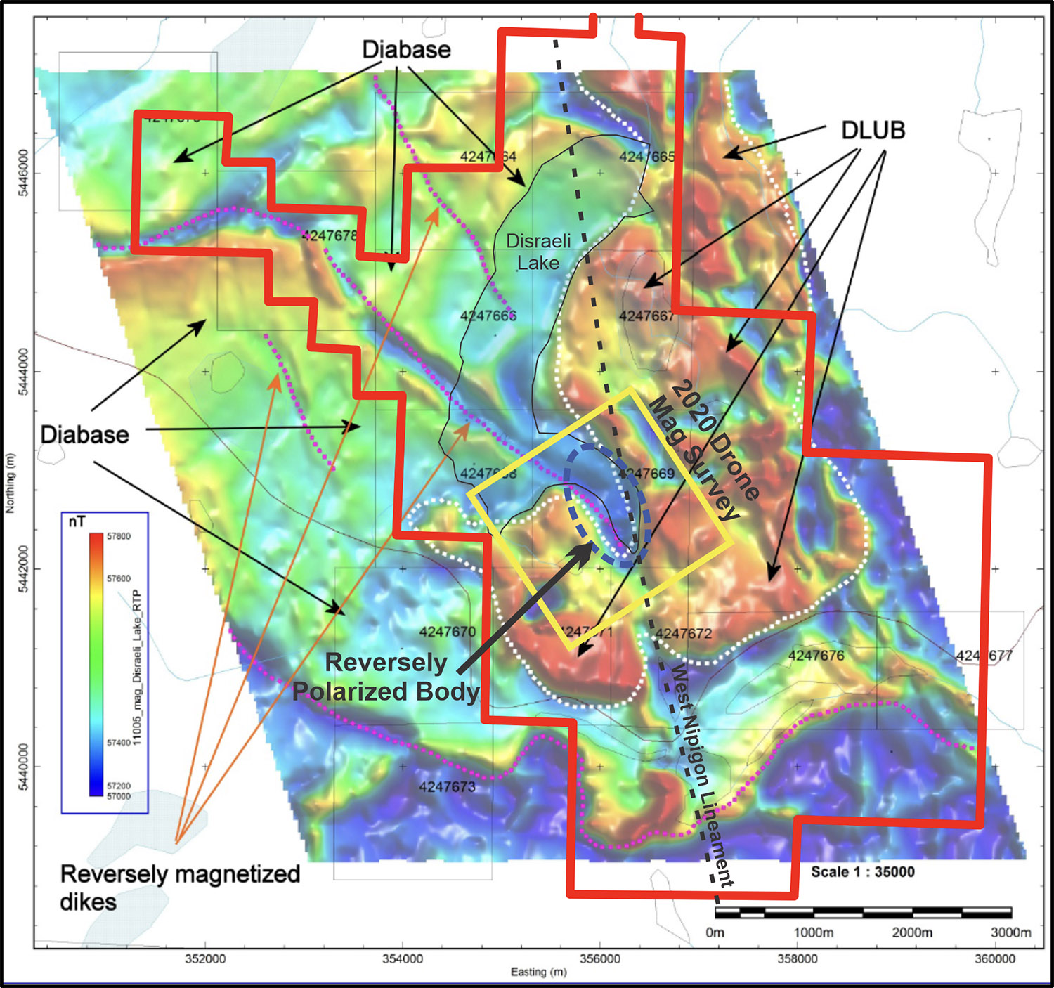
Figure 3: 2011, 100-meter spaced AeroTEM survey, total magnetic field reduced to the pole (TMI-RTP) with 2014 Condor Geophysics interpretation highlighting the Disraeli ultramafic body (DLUB). Note the reversely polarised body in the southeast bay (Hook Bay) of Disraeli Lake. The Disraeli property boundary shown in red, 2020 detailed drone survey area outlined in yellow, and the Hook Bay reversely polarized body shown by dashed blue line.
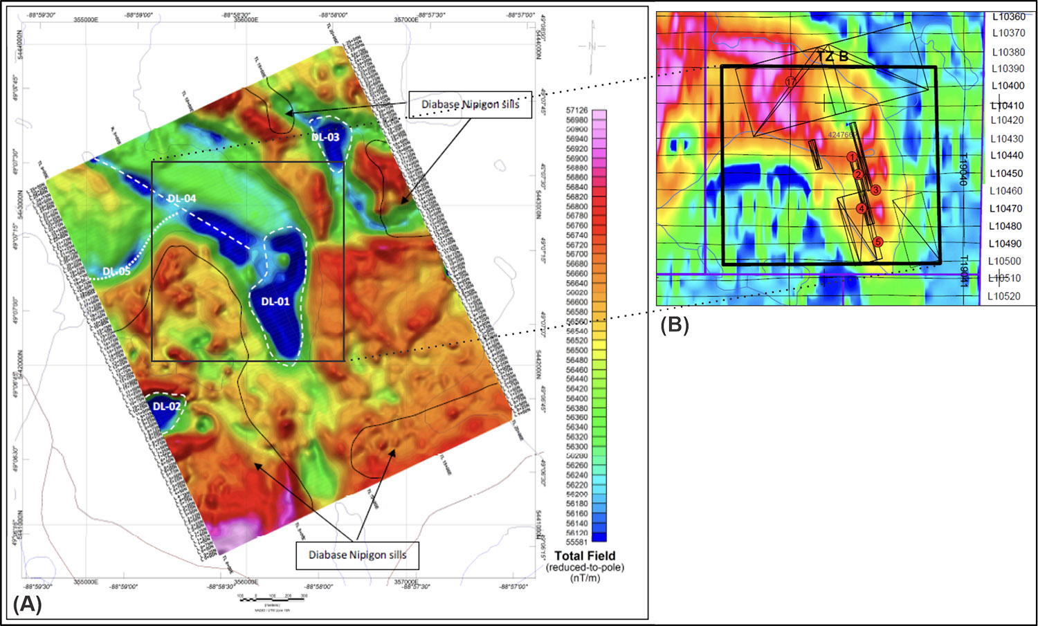
Figure 4: Image (A) is the 2020 drone based, 25-meter spaced survey, TMI-RTP mag, target DL-01 is the Hook Bay strongly magnetic reversely polarized body. Image (B) are EM anomaly picks and Maxwell plates models by Condor Consulting in 2014 from the 2011 AreoTEM survey. The background image is a 60-meter conductivity depth slice.
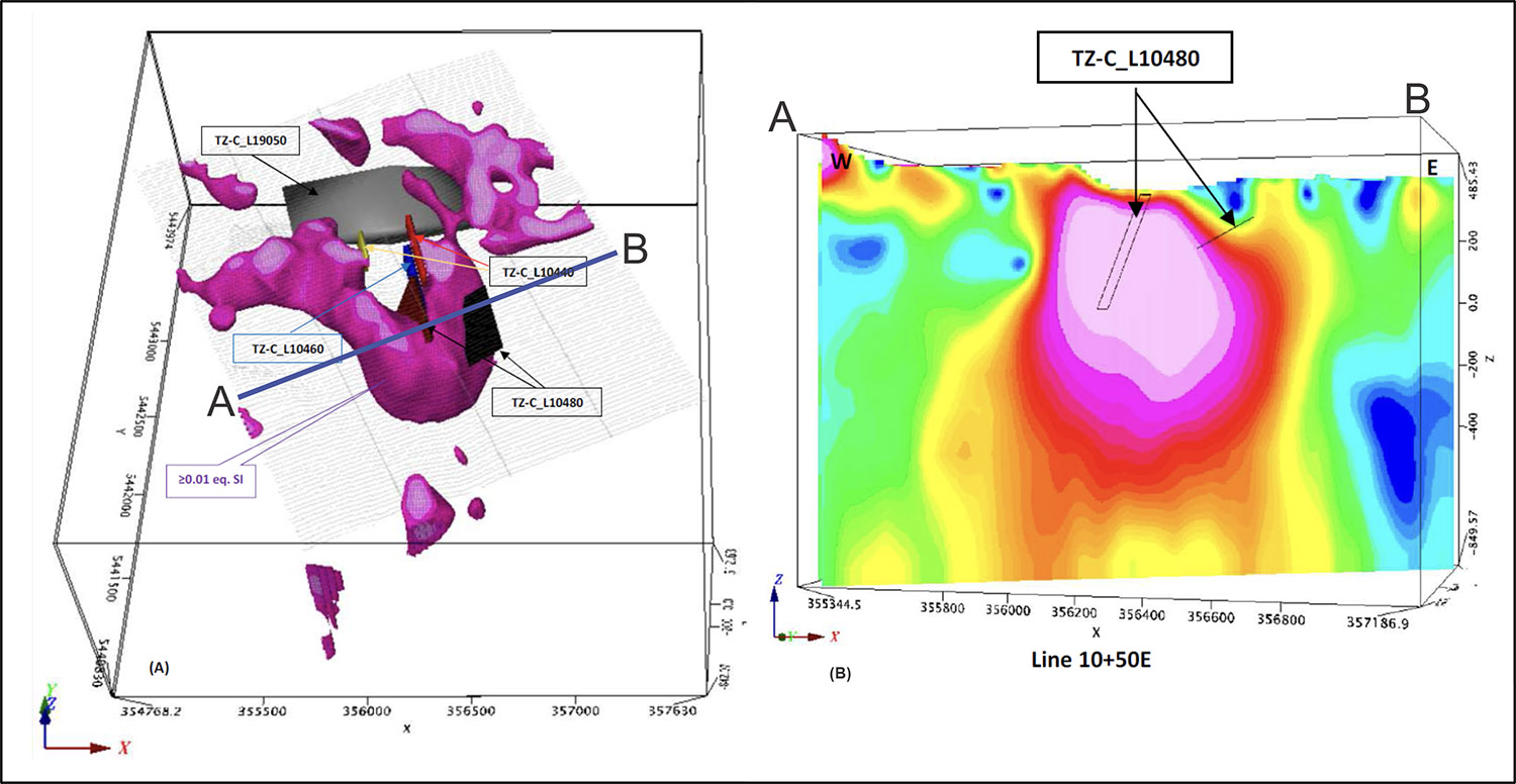
Figure 5: Image (A) is an isometric view of the Hook Bay highly magnetic body looking north. Image (A) was generated by Abitibi Geophysics using VOXI Magnetization Vector Inversion technology (MVI) magnetic susceptibility model plotted as an isosurface using the 2020 drone magnetic survey data, MVI is considered a better technique for modelling overall magnetic susceptibility in areas like Disraeli where both positively and reversely polarized rocks occur. Image (B) is a cross section along Line A-B through the MVI magnetic susceptibility model looking north. Both images include Maxwell plate EM picks from Condor Consulting 2014 interpretation of the 2011 AeroTEM survey.
Exploration
In January 2021, the Company constructed a 2-kilometre ice road and then drilled 5 ice-based holes totalling 1,233 meters to test several airborne EM conductors and a reversely polarized magnetic body under Hook bay of Disraeli Lake. One conductor was found to be caused by massive magnetite copper-cobalt-nickel Skarn, while several of the airborne EM conductors proved to be the result of lake sediments (Figure 6), (Table 1). The reversely polarized magnetic body requires additional follow up as it was not adequately explained, it may be the result of a reversely polarized granophyric sill located below the Disraeli Intrusion and/or a magnetite skarn.
Borehole EM surveys were conducted on all holes drilled and were hindered by very high background conductivity, which may be the result of saline brines in the Sibley Formation sediments. Of particular note was an off-hole EM conductor identified at the Sibley - Quetico (metasedimentary basement rocks) contact (Figure 7). Unseasonably warm conditions in early March resulted in deterioration of the ice road, cutting the drill program short and thus this target was not able to be tested. This target remains a priority target.
The copper-cobalt-nickel magnetite skarn is of particular interest as it is enriched in cobalt (Table 1). The mineralization intersected in the recent program is very similar to skarn mineralization intersected 1.5 kilometers to the south in holes U17-01 and U17-02 by a previous operator. These holes intersected up to 0.13 % cobalt over 2.0 meters and 0.16 % cobalt over 0.45 meters respectively.
This cobalt bearing skarn-style mineralization has now been intersected by 4 holes on the Disraeli project indicating it is much more widespread that previously thought. The mineralization is hosted in the carbonate-rich (dolomite) Rossport unit of the Sibley Formation, mostly likely representing replacement of stromatolitic beds within the sediments. It consists of massive to stringer magnetite with 10-20% sulphides consisting of pyrite, pyrrhotite, and chalcopyrite (Figure 8). This skarn mineralization is indicative of widespread hydrothermal alteration associated with either the Disraeli intrusion or another unknown mafic-ultramafic intrusion at depth. Additional, copper mineralization is known to occur in the greater Disraeli Lake area as chalcocite and malachite hosted in stromatolites with the Sibley sediments, grab samples collected by the Ministry of Northern development in 2011 returned up to 1.57% Cu (Mineral Deposit Index MDI52H02NW00002) from this style of mineralization. All of this indicates a significant magmatic hydrothermal system was present in the Disraeli Lake area, and suggests thicker and higher-grade areas of cobalt skarn mineralization are yet to be discovered.
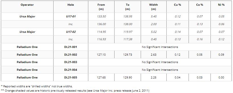
Table 1: Disraeli Significant Drill Hole Intersections
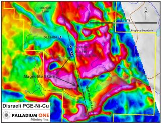
Figure 6: Disraeli drill hole location map, background is total field magnetics.
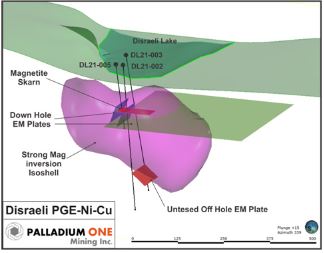
Figure 7: Disraeli Project Isometric view looking north-northwest, showing the location of holes DL21-002, 003 and 005 along with down Hole EM plates and VOXI inverted strongly magnetic body.
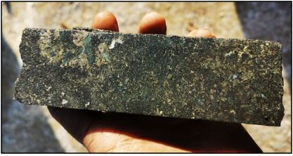
Figure 8: Cu-Co-Ni mineralized massive magnetite skarn mineralization form hole DL21-002.
Qualified Person
The technical information on this page has been reviewed and verified by Neil Pettigrew, M.Sc., P. Geo., Vice President of Exploration and a director of the Company and a Qualified Person as defined by National Instrument 43-101.
QA/QC
The drilling program was carried out under the supervision of Neil Pettigrew, M.Sc., P. Geo., Vice President of Exploration, and a Director of the Company
Drill core samples were split using a rock saw by Company staff, with half retained in the core box and stored onsite at the Tyko exploration camp core yard facility.
Samples were transported in secure bags directly from the logging facility at the onsite exploration camp, to the Activation Laboratories Ltd. (“Actlabs”) in Thunder Bay, Ontario. Actlabs, which is ISO 17025 accredited with CAN-P-1579 (Mineral Lab). In addition to ISO 17025 accreditation, Actlabs is accredited/certified to ISO 9001:2015. All samples are crushed to 2 millimeters with a 250-gram split pulverized to 105 microns. Analysis for PGEs is performed using a 30 grams fire assay with an ICP-OES finish and for Ni, Cu, and Co using 0.5 grams by 4 acid digestion with ICP-OES finish. Ni, Cu and Co samples over 1.0 wt% were re-analysed by ore grade methods using 4 acid digestion with ICP-OES finish.
Certified standards, blanks and crushed duplicates are placed in the sample stream at a rate of one QA/QC sample per 10 core samples. Results are analyzed for acceptance within the defined limits of the standard used before being released to the public.
Note:
All grades are insitu grades and accordingly do not take into account recovery rates.